Michael Lens, associate professor of urban planning and public policy, spoke to the Post and Courier about land use and zoning ordinances at the center of a dispute over a South Carolina turkey-shoot business. A neighbor’s complaint about the business — which invites customers to shoot at targets, with a turkey awarded to the best marksman —prompted a review of zoning decisions made decades ago. The turkey shoot was found in compliance with the law, which did not require a buffer between the gunfire and other properties and did not regulate hours of operation. But officials were left to ponder how to preserve the county’s character amid a rapidly growing population. The episode casts light on recurring frictions over land use ever since the U.S. began to rapidly suburbanize in the 1940s and 1950s. Governments have grappled with how to modernize zoning regulations to accommodate more development, Lens said. “It just involves a lot of trade-offs.”
The median price of a home in Los Angeles is expected to soon hit $1 million, and UCLA Luskin’s Michael Manville recently told the Guardian that “homeownership for many people is now out of reach.” The professor of urban planning noted that most homebuyers do not have $400,000 for a typical 40% down payment, nor $4,000 a month to put toward mortgage payments. “The million-dollar home price is like the tip of a big iceberg” because soaring home prices also impact the cost of rental homes and apartments, contributing to the ongoing homelessness crisis in California, he explained. Manville also spoke to Bloomberg News about one approach to tackling the affordable housing crisis: building more duplexes, triplexes and similar “middle housing” options. Decades ago, when there was a lot more empty land, large areas were zoned for single-family homes. “There was always the next valley to go to,” Manville said. “Now, that’s much harder.”
Associate Professor Michael Lens wrote an opinion piece for the Los Angeles Times on housing and land use reform in Los Angeles. Lens argues that L.A.’s geographic sprawl can be beneficial in terms of balancing housing density “that works for Californians.” Land use laws that discourage building for density can be reformed to provide alternatives to single-family neighborhoods by re-framing planning for housing around job-rich, medium-density urban hubs. “This does not necessarily mean obliterating the urban forms and communities that have been built in the past century. But without some densification, we’ll keep pushing people and development into the Inland Empire and other outlying areas (which is already happening),” he wrote. The result is “more punishing commutes and, in all likelihood, still expensive housing.” Lens also was quoted in an L.A. Times article about landlords’ objections to a continuing rent freeze, saying the pandemic sent policymakers “reaching for the emergency button,” but now the city should look at policies like expanding housing subsidies rather than extending the freeze.
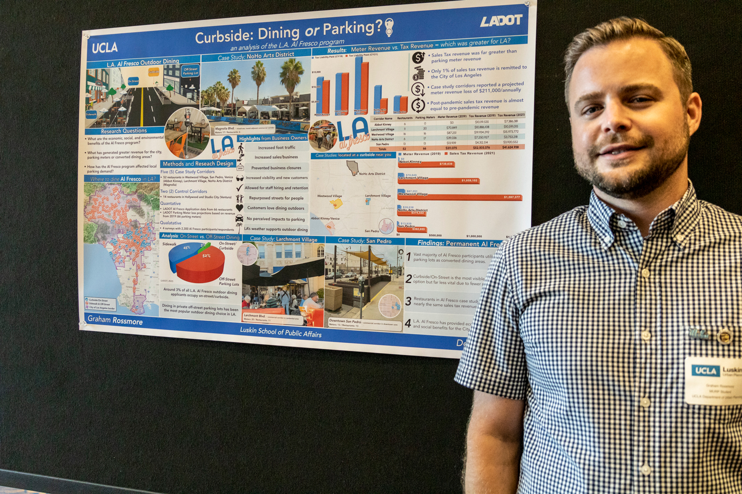
In recent months, UCLA Luskin graduate Graham Rossmore has become a go-to expert for Los Angeles officials who are studying the economic pros and cons of continuing the al fresco dining that sprang up during the COVID-19 pandemic.
Does the economic benefit of allowing outdoor dining on public property outweigh a loss of revenue from, say, parking meters?
Rossmore received his master’s degree in urban planning in June 2023, and he dove deep into that question and a host of related ones as part of his capstone project at UCLA Luskin. He found that, indeed, continuing outdoor dining would outweigh a loss of various revenue sources — along with a whole bunch of other benefits.
“Al fresco encourages more people walking, or people choosing to take alternative modes of transportation — and enjoying their neighborhoods,” Rossmore said.
Throughout UCLA Luskin, capstone projects like those in Urban Planning offer a chance for soon-to-graduate students to wrap up their UCLA education with a monthslong examination of a timely public policy issue. While student researchers often work with local government agencies as their clients, few have the opportunity to influence citywide policy decisions immediately. But that’s what happened for Rossmore.
An American born in Canada, Rossmore lived without a car for much of his 15 years in California. Perhaps not surprisingly, then, he began his urban planning studies with a focus on rail and bus transportation — which led him to a course taught by Donald Shoup, the distinguished research professor at UCLA Luskin who is perhaps the world’s foremost expert on parking.
“For whatever reason, parking policy speaks to me,” Rossmore said.
Shoup’s class gave Rossmore the opportunity to explore whether cities should continue what had begun as a temporary COVID-19 response — converting outdoor public spaces into al fresco dining spots. He focused on the Rustic Canyon neighborhood of Pacific Palisades, where he lived at the time.
The number of off-street parking lots there outnumbered restaurants, and when restaurants converted some of that parking into al fresco dining, they took it seriously.
“They spent a lot of money,” Rossmore said. “They have lights. They have fixtures. They’ve got heating. They’ve got seats.” He said some restaurant owners he interviewed in spring 2022 told him they had doubled their sales and expanded their customer bases.
A summer internship followed with the office of Los Angeles City Councilman Paul Krekorian, who is now council president. One connection led to another, and Rossmore soon found himself working part time on the city’s Al Fresco Dining program in the parking meters division of the Los Angeles Department of Transportation.
Rossmore and other students pursuing master’s degrees in urban planning present their capstone research findings during a poster session each year. Photo by Les Dunseith
The project helped inform his capstone project, and vice versa. He learned the ins and outs of sales tax, of which 99% goes to the state, while typically 1% is remitted to the city. Yet Rossmore found that the al fresco dining generated enough tax revenue to offset lost revenue from parking meters.
During presentations to LADOT leaders and city officials, Rossmore has highlighted many of the broader benefits of al fresco dining for local municipalities: Greater sales tax revenue represents higher overall economic output, which means happier business owners, customers and city officials.
He also discovered another plus of outdoor dining: More residents tend to eat closer to where they live, which brings all the benefits associated with reduced vehicle use.
“And when we take away parking spots, restaurants haven’t reported a lack of customers or people coming in and complaining, ‘I don’t dine here anymore because I can’t park,’” Rossmore said.
Rossmore’s capstone report analyzes three formats for al fresco dining — on sidewalks, on streets in formerly metered spaces and in private lots — each of which entails its own regulatory considerations. Sidewalk dining, for example, falls under the purview of the Department of Building and Safety because of the need to meet safety codes and comply with the Americans with Disabilities Act.
On-street dining is the focus of LADOT’s roadway dining initiative, and an LADOT report that cited Rossmore’s findings was sent to the Los Angeles City Council, recommending that businesses be allowed to offer curbside al fresco dining, so long as they pay a fee that would help offset lost parking revenue.
Even with his capstone project complete, Rossmore, who also serves on the Los Feliz Neighborhood Council, has continued researching the subject. He has also analyzed the costs and benefits of al fresco dining in several other corridors — Larchmont Village, San Pedro, Westwood Village, the NoHo Arts District in North Hollywood and Venice’s Abbot Kinney Boulevard.
“The sales tax in 2022 in most of these corridors is almost double pre-pandemic levels,” said Rossmore, noting that other parts of the city that lack al fresco dining, like Hollywood and Studio City, are collecting significantly less sales tax revenue than they were before COVID-19. “That suggests that the al fresco program not only was successful in keeping the businesses afloat — so that they didn’t close during the pandemic — but it also increased sales tax for the city and generated more profit for the restaurants overall.”
Rossmore also was asked to present his capstone research to officials at the Department of City Planning, which is developing the ordinance for outdoor dining in private, off-street parking lots. On April 27, he presented findings that only around 3% of al fresco dining was in on-street metered spaces.
“My client and I were able to speak at the public hearing and to demonstrate how off-street dining is the lion’s share of the program,” Rossmore said.
Soon after, the City Planning Commission issued a letter of determination to create a path for businesses to make outdoor dining a permanent feature. And the city’s chief executive has weighed in.
“Al fresco shows us a better way that supports small businesses, creates jobs and adds vibrancy to our neighborhoods,” Mayor Karen Bass said in a statement. “I directed city departments to work together to make this a permanent al fresco program that incorporates everything that made the temporary program successful and to make the process simple and easy to navigate for our restaurants.”
Two years ago, Graham Rossmore had no inkling he’d find himself telling city officials why it makes sense to convert public spaces into outdoor dining spots.
“In my personal statement to get into UCLA Luskin, I didn’t say, ‘Leaving this program, I’m going to be a parking expert,’” he said with a smile of satisfaction. “But that’s where I’ve ended up.”
View additional photos from Careers, Capstones and Conversation, a showcase of each year’s individual urban planning projects
“But it dawned on me that a really important foundational piece of work that was published one-half century ago, 50 years ago, was Marty Wach’s paper on accessibility,” said Cervero during a Feb. 28 presentation in honor of his former urban planning mentor and colleague. “And why don’t I wrap my talk … around the theme of that paper and try to show how it really shaped my own research in this field and, I would suggest, generations of other people as well.”
Titled “Physical Accessibility as a Social Indicator,” the article by Wachs and T. Gordon Kumagai continues to influence planning policy, said Cervero, who earned his doctorate in urban planning at UCLA in 1980 and joined UC Berkeley’s city and regional planning faculty, where he remained until 2016.
“The article really highlights a number of different contexts of which accessibility should really be an overarching principle that guides what we do in this field of urban planning and transportation,” Cervero said.
During introductory remarks, UCLA Luskin Professor Brian Taylor mentioned that the lecture was the first in the series to be presented without Wachs himself in attendance. The longtime urban planning scholar taught at both UCLA and UC Berkeley before his death in 2021. Members of the Wachs family, including his wife, Helen, were in attendance.
Presented in conjunction with the Luskin Lecture Series, Cervero’s talk was titled, “Accessibility, Social Equity, and Contemporary Policy Debates,” and he spoke about how the concepts put forth 50 years before still have relevance today, especially in regard to how access to transportation contributes to the well-being of people living in cities.
“Marty made the point with his co-author that this sensibility happens at multiple scales. It’s regional access to jobs or medical facilities, but it’s also at the micro-scale of ‘Do you have access to, say, a bus?’” said Cervero, who said he built on this notion in his own research about socioeconomic matching in terms of the realities of transportation access. A person might live in a transit-rich area, for example, “but if you’re in a wheelchair, and the buses don’t have wheelchair ramps, then you don’t have great transit access.”
In the 1970s, few scholars prior to Wachs had written about these types of human components to transportation access. “To me, it was truly revolutionary,” Cervero said.
For example, Cervero found that people living in central city neighborhoods often bear disproportionately higher costs for transportation services. Because they make frequent off-peak trips for necessities like groceries, they end up paying a lot more than affluent suburbanites taking fewer trips over longer distances.
The disparity also was apparent when he and other researchers looked at why people who seemed to have public transit options readily available to them choose to rely primarily on their vehicles instead.
“A lot of these individuals were people like working moms who had very complex travel patterns,” Cervero said. “They have a child to drop off at the child care center and then go to their job. They were taking vocational courses at night and had to get there at a time when public transit service was bad. They had split-shift weekend jobs when transit services are notoriously lousy. So, they need a car.”
In looking at the concepts articulated by Wachs so many years before, Cervero also found lessons that can be applied to some of today’s planning and policy debates. One example is the idea of a “15-minute city,” a place designed by planners to ensure that most people have ready access not just to work but to the other necessities of daily life within 15 minutes of their homes.
The idea is laudable, but it has its critics.
“If you really insist on this, you potentially stifle economic competition. Companies don’t want to thinly distribute activities everywhere,” said Cervero, as some in the audience of UCLA faculty, staff, students and alumni nodded their heads in agreement. “So, this idea of a 15-minute city really runs in the face of what economists have long argued are important economic drivers towards the economic growth and performance of a city.”
In his career, Cervero has consulted on transportation and urban planning projects worldwide, including recently in Singapore. “They’ve come up with this idea of the 20-minute town and the 45-minute city. You can reach a lot of things within 20 minutes. But when it comes to employment, when it comes to going to see a sporting event or buying a car or going to a regional hospital with specialized medical care, that’s a 45-minute city. So, I think we’re getting a lot better articulation and sensible policy.”
During a Q&A session after his formal presentation, Cervero spoke with UCLA Professor Adam Millard-Ball and took questions from the audience. When asked to talk more about his global experience, he explained that much of the scholarly work to date has focused on urban life in the United States and Europe.
Some of today’s researchers focus on climate change impacts and how to find “a little more efficiency out of electric mobility or ridesharing or whatever. But in the grand scheme of things, over the next 20 or 30 years, 80% to 90% of urbanization is not going to happen in the Global North. It’s going to be in south Asia and Africa, and whatever happens there is going to swamp any and everything we do here, particularly in the rates of carbon emissions and so forth.”
In the developed world, the focus is often on how to get people from the central cores to jobs in suburbia. That’s less true in places like Mexico, South America, Indonesia and other parts of Asia.
“It’s a totally different landscape. Most of the poor are not in cities but in far-flung suburbs or towns. When you’re talking about lack of access, it’s a two- to three-hour, one-way daily commute,” Cervero said. “The amount of time and resources you have to invest is enormous just getting to and from where you need to be in order to have the earnings to cover basic needs.”
He was also asked about the impact of the COVID-19 pandemic and the resulting rise in remote work.
“Historically, we think of physical proximity,” said Cervero, noting that when workers have highly specialized skill sets they depend on interactions in teams of people with other specialized skills to thrive.
“The whole idea of access being tied to location is being somewhat thrown around by all these rapidly evolving, powerful kinds of technological advances,” he said. “Technology is transforming. The notion of physical proximity as we all know it has long driven the idea of cooperation. But maybe it happens less.”
Established by students, the Wachs Lecture Series features prominent and innovative scholars and policymakers in the field of transportation. The UCLA Luskin Lecture series brings together scholars with local and national leaders to discuss solutions to society’s most pressing problems. This event was organized by UCLA’s Luskin School of Public Affairs and Institute of Transportation Studies, for which Taylor has served as the director and Millard-Ball the interim director. Cervero was the director of UC Berkeley’s counterpart to ITS for many years.
More than 200 people celebrated the architectural and cultural significance of the West Los Angeles Civic Center and Courthouse on Sunday, Oct. 2, during a public space activation. The event brought together UCLA architecture and urban planning students, public space advocacy organizations, and longtime users of the space in the third and final event organized by UCLA’s (Un)Common Public Space Group. Participants gathered to make use of the space and envision future uses of the bandshell, ledges and pathways, constructing skate obstacles and devising other amenities, learning about the history of the space, and enjoying music and food. The event encouraged dialogue among policymakers, developers and the public to safeguard community amenities. It also connected UCLA-based public space research with the city’s redevelopment plans for the space and engaged with the local knowledge and perspectives of advocacy organizations near the courthouse. Keegan Guizard from College Skateboarding and Alec Beck from the Skatepark Project hosted skateboard contests, highlighting the area’s history of skateboarding activism. The L.A. Conservancy informed participants about the historical importance of mid-century modern architecture, and students constructed future amenities like modular street furniture and colorful shade structures. Over 140 signatures were gathered for public petitions and comments to preserve community amenities and obstacles in the space’s future redevelopment. The (Un)Common Public Space Group activates public space with and for underrepresented and underserved communities in pursuit of spatial justice. The series was supported by the UCLA Lewis Center for Regional Policy Studies and the UCLA Urban Humanities Initiative. — Chris Giamarino
Susanna Hecht, professor of urban planning at UCLA Luskin and director of the UCLA Center for Brazilian Studies, was a recent guest on the ’74 Podcast series “Urban Nature.” Hecht, who holds appointments in geography and UCLA’s Institute of the Environment and Sustainability, discussed her five decades of research and engagement with the Amazon as well as changes in the region over the past century. Topics of the program, recorded in July, included the ideological view of the Amazon as a frontier. “It was not actually ever a frontier,” said Hecht, arguing “that ideology of frontier is the ideology of conquest. It doesn’t reflect a reality.” Hecht, an authority on forest transitions and sustainable agriculture, as well as a founding thinker in the field of political ecology, described the Amazon as a “major center of civilizations … a major area with large-scale urban structures with linkages between those structures,” as opposed to a void that is subject to what she calls a “development tsunami.”
M. Nolan Gray, a doctoral student in urban planning at UCLA Luskin, argues in a newly published book that America’s century-old land use planning practice of zoning needs to go. Since the first zoning codes appeared in 1916 and were given U.S. Supreme Court sanction in 1926, Gray writes, “The arbitrary lines on zoning maps across the country have come to dictate where Americans may live and work, forcing cities into a pattern of growth that is segregated and sprawling.” In “Arbitrary Lines: How Zoning Broke the American City and How to Fix It” (Island Press, 2022), Gray provides an overview of the history of zoning. He offers critiques of zoning’s role in four areas: increasing housing costs, restricting growth in America’s most productive cities, institutionalizing racial and economic segregation, and mandating sprawl. Gray, a professional city planner who has worked on zoning policy in New York, ties “Arbitrary Lines” together by detailing current efforts to reform zoning, presenting a case to abolish zoning and showing how a post-zoning United States might work in practice. Gray serves as research director for California YIMBY and has contributed articles to publications that include Bloomberg City Lab, the Atlantic and Forbes. In his introduction to the book, Gray writes that it is meant to be fundamentally constructive, and “… beyond merely arguing against the arbitrary lines that hold us back, this book is a reminder that a more affordable, prosperous, equitable and sustainable America is possible.”
For Jasmine Hill and four other new full-time faculty at the Luskin School, it will be a homecoming.
The 2011 UCLA alumna, who served as student body president during her senior year as an undergraduate, will begin doing research and teaching at her alma mater as an assistant professor of public policy this summer.
“I think it’s always people’s dream to come back to their undergraduate institution, especially if they had a positive experience, and that was certainly the case for me,” Hill said. “Having received my graduate training at a private school, I got to see how much I value UCLA and public education.”
Hill’s work focuses on economic inequality, specifically on obstacles to social mobility for Black Americans. At UCLA Luskin, she will teach qualitative methods, plus a course about how seemingly well-intentioned policies can lead to racial inequality.
“In the wake of the assassination of George Floyd, I’m thinking a great deal about the disconnect between decision-makers and the public who wants to transform systems of power. If done correctly, I see qualitative methods as a tool to amplify the perspectives of the people and center the needs, and the concerns, of underserved populations,” she said.
Hill is passionate about mentoring students, especially those who traditionally have been marginalized. “I’m excited to support Luskin students who are organizing and fostering social change,” she said. “I’m motivated
and inspired
by them.”
Another new faculty member with direct ties to campus is Veronica Terriquez, who earned her Ph.D. in sociology in 2009 at UCLA and will become a professor of urban planning with a joint appointment in Chicana/o and Central American Studies. She will also lead the UCLA Chicano Studies Research Center. She was previously an associate professor of sociology at UC Santa Cruz.
Terriquez focuses on social inequality, immigrant incorporation and political participation, taking an intersectional approach to understanding how individuals and groups reproduce or challenge patterns of social inequality. Much of her research has implications for policies affecting low-income, immigrant and Latino communities.
“As the daughter of Mexican immigrants, I prioritize conducting research that has implications for education reform, immigrant rights, labor rights and racial justice efforts,” said Terriquez, who also holds degrees from Harvard and UC Berkeley.
Mark Vestal has strong personal links not just to UCLA but also to Los Angeles. He was born in Inglewood and can trace his family lineage in the city to the late 1800s. He attended local schools and completed his undergraduate, master’s and doctoral degrees at UCLA.
Vestal, who completed his Ph.D. in history in 2020, joined UCLA Luskin Urban Planning in January as a postdoctoral scholar and will transition to assistant professor in July.
“Being able to teach and do research in the city I have so much invested in, personally — in terms of personal experience, politically and also in terms of family ancestry — perhaps it should be an entitlement, but it feels like an incredible privilege,” Vestal said.
His interest lies in the Black experience of private property, he explained, looking closely at the history of discriminatory planning and housing policy in Los Angeles and beyond.
Vestal is developing his doctoral dissertation into a book, describing it as a social history of working-class property and politics. The findings of his thesis will “force urban historians, and anyone concerned with housing policy, to rethink the central problem of race and housing in the United States.”
Also joining UCLA Luskin Urban Planning in January was Adam Millard-Ball, an associate professor whose previous academic post was in environmental studies at UC Santa Cruz. He holds a doctorate from Stanford and studies environmental economics and transportation.
Working remotely amid the pandemic, Millard-Ball has already taught a class in transportation and environmental issues and another on urban data science.
Millard-Ball originally hails from the south of England. Trained as an economist, geographer and planner, his scholarship analyzes the environmental consequences of transportation and land-use decisions, including parking. He also examines policies to reduce greenhouse gas emissions.
“Much of my current work is about street network sprawl worldwide — quantifying which places have been really successful in providing connected streets, which are good for walking and biking,” he said.
Noting that transportation is the largest source of emissions in California, Millard-Ball explained, “I’m interested in what can be done to bend that curve.”
The fifth new faculty addition also has UCLA teaching experience. Margaret “Maggie” Thomas, who will become an assistant professor of social welfare, previously served as a lecturer for a second-year graduate course on poverty and welfare.
“I was particularly glad to get to teach last year as a way to really be connected with Luskin in that interim year,” said Thomas, who finished her Ph.D. at Boston University in 2020, followed by postdoctoral work at Columbia University. “It was just such a nice chance to get to know master’s students and start to get a little bit familiar with what the whole feel of teaching is like at Luskin and to meet some colleagues who are also teaching in the MSW program.”
Much of Thomas’ work is policy-oriented,
“so there’s a lot of really natural connections for me between social welfare, public policy and urban planning. Luskin offers such clear opportunities to collaborate with all three departments.”
Thomas holds degrees from Notre Dame and the University of Illinois. She focuses on children and families facing economic hardship, as well as children and youth from marginalized communities.
“We’ve heard conversations about hardship at the national level a lot more this year than we typically do. Whether it’s
food insecurity or housing hardship, the kinds of things I’ve been studying are only that much more prominent and bigger problems to solve,” she said.
With cities and suburbs across the United States facing well-documented affordable housing shortages, researchers for years have studied how government planning standards affect housing costs.
Those studies often examine how planning and zoning decisions affect traffic noise, whether neighborhood amenities can be reached by foot and other factors that can make a home more or less valuable.
A new paper expands this body of research by considering the housing, schools, parks and other infrastructure that go unbuilt in favor of wide streets.
The U.S. has some of the widest streets in the world. In 20 of the most populous counties, the median residential street plus sidewalks is 50 feet wide, with the dollar value of land used for streets sometimes stretching into six figures, according to the research in the Journal of the American Planning Association.
A narrow street in Shibuya City, Tokyo. Photo by Tim Foster / Unsplash
Wide streets are less common in some other countries. Certain streets in Japan, for example, are much narrower. Developments in Tokyo since 1990 have average street widths of 16 feet, noted Adam Millard-Ball, an associate professor of urban planning at the UCLA Luskin School of Public Affairs and author of the new paper.
“One of the best ways to alleviate the housing crisis is to build more housing,” he said. “To the extent that narrower streets allow developers to build more housing, that will address the No. 1 issue with housing right now.”
The median residential street in Arizona’s Maricopa County, which includes Phoenix, is 50 feet wide, according to Millard-Ball’s sample of counties.
The median width of a residential street in Middlesex County, Massachusetts, which includes Cambridge, is 40 feet — the narrowest of the group.
The widest streets in the sample are in Cook County, Illinois, which includes Chicago. There, the median residential street is nearly 65 feet wide.
The 50-foot standard
For urban planners, a street is called a right of way. The paved section is the roadway.
A right of way includes the roadway as well as sidewalks, if any, along with space for drainage, utility poles and other public infrastructure. It’s the land usually owned by a city or county that the public has the right to use and make its way through by car, bicycle, foot or other mode. Neighbors waving hello across the sidewalk’s edge of their properties are waving across the right of way.
The median 50-foot right of way Millard-Ball documents stems from nearly a century of history in U.S. planning. After the home mortgage system collapsed during the Great Depression, the federal government stepped in and established the Federal Housing Administration in 1934.
The agency’s mortgage insurance and financial assistance for homebuyers represented “the most ambitious suburbanization plan in United States history,” wrote Michael Southworth and Eran Ben-Joseph in a 1995 Journal of the American Planning Association article that reviews the historical rise of U.S. suburbs.
To protect the government’s unprecedented investment in home ownership, mostly for white Americans, developers had to have detailed plans approved by the agency. The agency encouraged cul-de-sacs for new developments and favored plans that discouraged through traffic.
“Moreover, the FHA, unlike other planning agencies, was largely run by representatives of real estate and banking, so developers felt that its intervention protected their interests,” Southworth and Ben-Joseph wrote.
If developers wanted to build homes that would benefit from federal financial backing, rights of way had to be at least 50 feet wide, Millard-Ball explained in his new paper, “The Width and Value of Residential Streets.”
Six-figure values
To understand the value of land used for streets, Millard-Ball drew on research from the Federal Housing Finance Agency that estimates the value of quarter-acre lots zoned for single-family homes across the country. The value of the land used for streets can be substantial in places where low population density and high housing costs converge.
Santa Clara County, California, which includes San Jose, has the most valuable streets in the sample at $146,000 per tax parcel. That’s roughly 40% of the median price of an existing single-family home sold in the U.S. in April 2021, according to data from the National Association of Realtors.
“One of the best ways to alleviate the housing crisis is to build more housing. To the extent that narrower streets allow developers to build more housing, that will address the No. 1 issue with housing right now.”
— Adam Millard-Ball, UCLA Luskin
New York City, by contrast, has high housing costs but also high density — large apartment buildings are common. Tens of thousands of people live within each square mile. The land beneath streets in Queens, for example, is worth $36,000 per parcel.
At the other end of the value spectrum, streets are worth $7,000 per parcel in Bexar County, Texas, which includes San Antonio. But land values and street widths can vary greatly within counties.
Terra Vista, a small street in a subdivision 25 miles north of San Antonio, is 52 feet wide and has a land value of $43,288 per parcel. All the land under residential streets in Millard-Ball’s 20 counties is worth nearly $1 trillion in total.
Millard-Ball noted that street land value estimates per parcel are likely low for high-cost, dense cities, which often zone for multifamily buildings over single-family homes.
For example, an Italian specialty food store in the Mission District of San Francisco sold its parking lot for $3 million in 2018 — roughly $36 million per acre, by Millard-Ball’s calculation — to make way for a five-story, 18-unit building, according to the news site Mission Local.
Most U.S. counties regulate how and where new housing and business developments are built, according to the National Association of Counties, a nonprofit organization that represents U.S. county governments.
Many large cities do the same.
It would be overly costly for cities and counties to change the width of existing streets, particularly with local governments facing budget shortfalls during the pandemic.
Still, the estimates in the new paper can be instructive for planning officials in places like Bexar, one of the fastest growing counties in the U.S., as they permit developments to accommodate new and current residents.
“The values are an indication that cities should be making it easier to use streets for something other than roadways and parking,” Millard-Ball said. “A good analogy is that during COVID, one use of streets has been for outdoor dining. It’s recognition that this land is more valuable to the community if we can use it for people to get together and eat in a safer environment outdoors, than as a parking space or travel lane for cars.”
He continued: “The point is that desolate asphalt is doing nobody any good — not the city, not property owners, not anyone. Cities are often keen to widen the right of way with new developments. Say you want to develop a new apartment building. Often, the city will say, ‘Sure, but you have to give up some land so we can add a turn lane, or widen the sidewalk.’ If cities can widen the right of way, why can’t they narrow it in exchange for improvements that will benefit the public?”
Indeed, when a new residential building goes up, cities commonly require developers to widen streets, according to a 2017 paper in the Journal of Transport and Land Use by Michael Manville, another UCLA Luskin urban planner.
In the paper, Manville looked at how the requirement played out in Los Angeles from 2002 to 2012. He found the city’s predictions of increased traffic with the arrival of new buildings were often wrong, and “the standards the law is based on are in some ways unverifiable. Thus the law likely does little to reduce congestion and probably impedes housing development.”
Flexible design
City and county planning standards vary and change, but the federal 50-foot standard still often dominates residential street design. Still, it’s not always true that counties with more land to expand, like those in Texas, have wider streets. Dallas County, for example, specifies that new residential streets in subdivisions be at least 50 feet wide. The median width of residential streets there is exactly 50 feet, Millard-Ball finds.
A surveyor’s chain owned by John Johnson, appointed Surveyor General of Vermont in 1813. Photo by John Johnson Allen / National Museum of American History
Residential streets in Chicago, meanwhile, are typically 66 feet wide, according to city design standards. That roughly matches the length of the typical surveyor’s chain as the city grew throughout the 1800s and early 1900s. The surveyor’s chain was a tool made up of interlocking metal bars that land surveyors used to measure and mark the shapes of streets to be built.
Uniformity in street design made sense as the nation was expanding and infrastructure technologies were less advanced. But the takeaway for Millard-Ball is that maintaining rigidity in street design means fewer amenities and, potentially, less housing.
He wonders, for example, whether more streets could be built with parking cutouts only where there are no private driveways — providing a unique residential landscape alongside opportunities to use more of the built environment for activities other than driving.
“That would make construction drawings more complex,” Millard-Ball said. “The tradeoff is visual interest — and saving a lot of valuable land.”
The prospect of narrower streets raises the question of whether emergency vehicles would be able to pass, though some planners, and at least one report from the U.S. Department of Transportation, suggest smaller emergency vehicles could be an answer.
This article first appeared on The Journalist’s Resource and is republished here with slight revisions for local style under a Creative Commons license.