A Los Angeles Times column on rising anger over speeding, stunt driving and street racing in L.A. cited Michael Manville, associate professor of urban planning. In the wake of a high-speed crash in South Los Angeles that killed five people, residents from across the city are weighing in with stories of unchecked reckless driving in their neighborhoods. In mid-city Los Angeles, residents’ pleas for street safety improvements that would protect pedestrians, cyclists and motorists have gone unanswered, Manville said. On Melrose Avenue, “almost every weekend, we have burnouts and stunt bikers and all sorts of people driving dangerously,” he said. “We should enforce speed limits, but the best speed limit is a road that doesn’t let you speed. But our city engineers and City Council members for some reason think we need to have highways running through our neighborhoods.”
A CNN story on the climate adaptation strategies used by eight world cities described research conducted by V. Kelly Turner, co-director of the UCLA Luskin Center for Innovation. The article described Los Angeles’ use of cooling paint on city streets as part of a pilot project to measure the effect on surface and ambient temperatures. Turner, an assistant professor of urban planning, and research partner Ariane Middel of Arizona State University collected data from the project and found that treated street surfaces were cooled by about 10 degrees Fahrenheit. However, they also found that heat radiating from the streets elevated temperatures immediately above the surface. Another type of paint could yield different results, and the city is continuing the program to see what methods work best.
Donald Shoup, distinguished research professor of urban planning, spoke with NBC4 News about Los Angeles’ backlog of 50,000 complaints about broken sidewalks. An audit last year found that the city pays about $7 million a year to settle injury claims related to sidewalks in disrepair. “In L.A., the sidewalks are a disgrace,” Shoup said. “We could use them as an obstacle course for the 2028 Olympics.” California cities including Pasadena and Oakland have passed “point of sale” ordinances that require homeowners to fix damaged sidewalks in front of their properties when they sell their homes, Shoup said. “People ought to pay for sidewalk repairs when it’s convenient for them and when they have the cash available. And that is at the time of sale.” He added, however, that the sidewalks are currently so dangerous that the city must look for a quicker fix.
A San Francisco Chronicle article highlighted research findings by Urban Planning Associate Professor Adam Millard-Ball on the width of streets in San Francisco. In places with housing shortages, wide streets take up valuable land that could have been used to build more homes or other buildings, Millard-Ball said. While the average street in San Francisco is 50 feet wide, Millard-Ball proposed 16 feet as the functional minimum width for residential streets. In some areas of the city, streets are an average of 93 feet wide. Millard-Ball argued that in high-cost California counties like Santa Clara and San Francisco, the consequences of unnecessarily wide streets are enough to make the costs to narrow them worth it. For cities that are still growing, Millard-Ball suggested that planners build narrower streets to save land for housing. In established cities where narrowing the streets is not feasible, he proposed adapting unused street spaces into outdoor dining spaces, slow streets and other recreational spaces.
With cities and suburbs across the United States facing well-documented affordable housing shortages, researchers for years have studied how government planning standards affect housing costs.
Those studies often examine how planning and zoning decisions affect traffic noise, whether neighborhood amenities can be reached by foot and other factors that can make a home more or less valuable.
A new paper expands this body of research by considering the housing, schools, parks and other infrastructure that go unbuilt in favor of wide streets.
The U.S. has some of the widest streets in the world. In 20 of the most populous counties, the median residential street plus sidewalks is 50 feet wide, with the dollar value of land used for streets sometimes stretching into six figures, according to the research in the Journal of the American Planning Association.
A narrow street in Shibuya City, Tokyo. Photo by Tim Foster / Unsplash
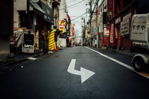
Wide streets are less common in some other countries. Certain streets in Japan, for example, are much narrower. Developments in Tokyo since 1990 have average street widths of 16 feet, noted Adam Millard-Ball, an associate professor of urban planning at the UCLA Luskin School of Public Affairs and author of the new paper.
“One of the best ways to alleviate the housing crisis is to build more housing,” he said. “To the extent that narrower streets allow developers to build more housing, that will address the No. 1 issue with housing right now.”
The median residential street in Arizona’s Maricopa County, which includes Phoenix, is 50 feet wide, according to Millard-Ball’s sample of counties.
The median width of a residential street in Middlesex County, Massachusetts, which includes Cambridge, is 40 feet — the narrowest of the group.
The widest streets in the sample are in Cook County, Illinois, which includes Chicago. There, the median residential street is nearly 65 feet wide.
The 50-foot standard
For urban planners, a street is called a right of way. The paved section is the roadway.
A right of way includes the roadway as well as sidewalks, if any, along with space for drainage, utility poles and other public infrastructure. It’s the land usually owned by a city or county that the public has the right to use and make its way through by car, bicycle, foot or other mode. Neighbors waving hello across the sidewalk’s edge of their properties are waving across the right of way.
The median 50-foot right of way Millard-Ball documents stems from nearly a century of history in U.S. planning. After the home mortgage system collapsed during the Great Depression, the federal government stepped in and established the Federal Housing Administration in 1934.
The agency’s mortgage insurance and financial assistance for homebuyers represented “the most ambitious suburbanization plan in United States history,” wrote Michael Southworth and Eran Ben-Joseph in a 1995 Journal of the American Planning Association article that reviews the historical rise of U.S. suburbs.
To protect the government’s unprecedented investment in home ownership, mostly for white Americans, developers had to have detailed plans approved by the agency. The agency encouraged cul-de-sacs for new developments and favored plans that discouraged through traffic.
“Moreover, the FHA, unlike other planning agencies, was largely run by representatives of real estate and banking, so developers felt that its intervention protected their interests,” Southworth and Ben-Joseph wrote.
If developers wanted to build homes that would benefit from federal financial backing, rights of way had to be at least 50 feet wide, Millard-Ball explained in his new paper, “The Width and Value of Residential Streets.”
Six-figure values
To understand the value of land used for streets, Millard-Ball drew on research from the Federal Housing Finance Agency that estimates the value of quarter-acre lots zoned for single-family homes across the country. The value of the land used for streets can be substantial in places where low population density and high housing costs converge.
Santa Clara County, California, which includes San Jose, has the most valuable streets in the sample at $146,000 per tax parcel. That’s roughly 40% of the median price of an existing single-family home sold in the U.S. in April 2021, according to data from the National Association of Realtors.
“One of the best ways to alleviate the housing crisis is to build more housing. To the extent that narrower streets allow developers to build more housing, that will address the No. 1 issue with housing right now.”
— Adam Millard-Ball, UCLA Luskin
New York City, by contrast, has high housing costs but also high density — large apartment buildings are common. Tens of thousands of people live within each square mile. The land beneath streets in Queens, for example, is worth $36,000 per parcel.
At the other end of the value spectrum, streets are worth $7,000 per parcel in Bexar County, Texas, which includes San Antonio. But land values and street widths can vary greatly within counties.
Terra Vista, a small street in a subdivision 25 miles north of San Antonio, is 52 feet wide and has a land value of $43,288 per parcel. All the land under residential streets in Millard-Ball’s 20 counties is worth nearly $1 trillion in total.
Millard-Ball noted that street land value estimates per parcel are likely low for high-cost, dense cities, which often zone for multifamily buildings over single-family homes.
For example, an Italian specialty food store in the Mission District of San Francisco sold its parking lot for $3 million in 2018 — roughly $36 million per acre, by Millard-Ball’s calculation — to make way for a five-story, 18-unit building, according to the news site Mission Local.
Most U.S. counties regulate how and where new housing and business developments are built, according to the National Association of Counties, a nonprofit organization that represents U.S. county governments.
Many large cities do the same.
It would be overly costly for cities and counties to change the width of existing streets, particularly with local governments facing budget shortfalls during the pandemic.
Still, the estimates in the new paper can be instructive for planning officials in places like Bexar, one of the fastest growing counties in the U.S., as they permit developments to accommodate new and current residents.
“The values are an indication that cities should be making it easier to use streets for something other than roadways and parking,” Millard-Ball said. “A good analogy is that during COVID, one use of streets has been for outdoor dining. It’s recognition that this land is more valuable to the community if we can use it for people to get together and eat in a safer environment outdoors, than as a parking space or travel lane for cars.”
He continued: “The point is that desolate asphalt is doing nobody any good — not the city, not property owners, not anyone. Cities are often keen to widen the right of way with new developments. Say you want to develop a new apartment building. Often, the city will say, ‘Sure, but you have to give up some land so we can add a turn lane, or widen the sidewalk.’ If cities can widen the right of way, why can’t they narrow it in exchange for improvements that will benefit the public?”
Indeed, when a new residential building goes up, cities commonly require developers to widen streets, according to a 2017 paper in the Journal of Transport and Land Use by Michael Manville, another UCLA Luskin urban planner.
In the paper, Manville looked at how the requirement played out in Los Angeles from 2002 to 2012. He found the city’s predictions of increased traffic with the arrival of new buildings were often wrong, and “the standards the law is based on are in some ways unverifiable. Thus the law likely does little to reduce congestion and probably impedes housing development.”
Flexible design
City and county planning standards vary and change, but the federal 50-foot standard still often dominates residential street design. Still, it’s not always true that counties with more land to expand, like those in Texas, have wider streets. Dallas County, for example, specifies that new residential streets in subdivisions be at least 50 feet wide. The median width of residential streets there is exactly 50 feet, Millard-Ball finds.
A surveyor’s chain owned by John Johnson, appointed Surveyor General of Vermont in 1813. Photo by John Johnson Allen / National Museum of American History
Residential streets in Chicago, meanwhile, are typically 66 feet wide, according to city design standards. That roughly matches the length of the typical surveyor’s chain as the city grew throughout the 1800s and early 1900s. The surveyor’s chain was a tool made up of interlocking metal bars that land surveyors used to measure and mark the shapes of streets to be built.
Uniformity in street design made sense as the nation was expanding and infrastructure technologies were less advanced. But the takeaway for Millard-Ball is that maintaining rigidity in street design means fewer amenities and, potentially, less housing.
He wonders, for example, whether more streets could be built with parking cutouts only where there are no private driveways — providing a unique residential landscape alongside opportunities to use more of the built environment for activities other than driving.
“That would make construction drawings more complex,” Millard-Ball said. “The tradeoff is visual interest — and saving a lot of valuable land.”
The prospect of narrower streets raises the question of whether emergency vehicles would be able to pass, though some planners, and at least one report from the U.S. Department of Transportation, suggest smaller emergency vehicles could be an answer.
This article first appeared on The Journalist’s Resource and is republished here with slight revisions for local style under a Creative Commons license.
Associate Professor of Urban Planning Adam Millard-Ball spoke to Bloomberg CityLab about his research on the land value of streets in the United States. Millard-Ball calculated the widths, land areas and land value of streets in 20 different counties in the U.S., and he found that streets averaged 55 feet wide, even in residential areas with low traffic. Streets are much wider in the United States than in other parts of the world. In the counties he surveyed, Millard-Ball found that streets took up 18% of the total land area. He said cities could use some of the land currently allocated to streets for bike lanes, transit, green spaces or housing. He also noted that decreasing standard street sizes could help reduce housing development costs. “People are already using streets for housing, just not in a sanctioned way,” he said. “Why do we rule out 20% of a city’s land and declare it off limits for that?”
Los Angeles’ ambitious plan to cool the city as the planet grows warmer is getting a boost from two university professors and a street-smart robot named MaRTy.
The researchers, from UCLA and Arizona State University, have completed the first on-site evaluation of the city’s Cool Streets program, one of several sustainability strategies outlined in Los Angeles’ 2019 Green New Deal.
By covering several blocks of road with a solar-reflective coating engineered to reduce surface temperatures, the city’s pilot program aims to test the cooling effects on an entire neighborhood. The researchers broadened the body of knowledge by collecting a sophisticated suite of measurements that simulate the experience of a pedestrian walking on the surface.
“Once you take things down to the street level, arguably you have to start thinking about the thermal load on people,” said V. Kelly Turner of the UCLA Luskin School of Public Affairs, who collaborated with Ariane Middel of ASU’s School of Arts, Media and Engineering.
The reflective coating aims to prevent asphalt from retaining heat, which contributes to the “urban heat island effect” that keeps cities from cooling down, even in the evening. But the study by Turner and Middel, newly published in the journal Environmental Research Letters, reveals an unintended, ground-level effect: The paint’s highly reflective properties can actually elevate pedestrians’ exposure to heat.
Imagine a scene that has become increasingly common as Angelenos shelter in place: families taking neighborhood walks, often with a dog in tow. On a coated road, the dog might appreciate the cooler surface beneath its paws. But the dog walkers might feel an uptick in heat reflected off the ground.
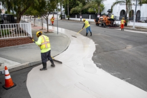
City workers apply a cooling paint on roads in Pacoima, part of Los Angeles’ strategy to combat climate change. Photo courtesy of Los Angeles Bureau of Street Services
“From an urban planning perspective, this idea of cool pavements is really innovative. Cool streets may be great for mitigating the urban heat island, if that’s the goal,” said Turner, who noted that the widespread use of the reflective paint on roofs, roads and other surfaces can reduce the amount of heat absorbed in the built environment.
However, she added, “If the goal is framed in terms of a public health benefit, we need to know a bit more, since the reflected radiation increases the heat load on a pedestrian walking over the surface.”
Turner and Middel hope their initial findings will open the door to further research that will help the public and private sectors fine-tune their green initiatives. In addition to gathering more information about cooling paint’s impact on human comfort and health, future studies could answer questions about cost-effectiveness, maintenance needs and the tradeoff between daytime glare and nighttime visibility, they said.
Putting MaRTy into action
To collect their cool pavement data, Turner and Middel took MaRTy for a spin on the streets of two Los Angeles neighborhoods chosen for the pilot project.
The robot is “essentially a garden cart that has a lot of meteorological sensors attached to it,” said Middel, who created the tool at ASU’s SHaDE Lab to calculate “mean radiant temperature” — the data set that gives MaRTy his name.
In addition to measuring surface and air temperature, wind speed and humidity, the robot collects information on long- and short-wave radiation to determine mean radiant temperature, which is a reliable predictor of thermal comfort for humans. MaRTy is also nimble enough to trundle along sidewalks, ravines or other locations where a pedestrian might wander, setting him apart from measurement tools mounted on street vehicles.
On a day in July 2019 when air temperatures hit the high 80s, the research team walked the blocks of the two neighborhoods, in Pacoima and Sun Valley, from 11 a.m. to 9 p.m. They found that the coated roadways were cooler to the touch, by as much as 11 degrees Fahrenheit, compared with nearby untreated asphalt — meaning the paint successfully lowered surface temperature, as it was designed to.
However, Turner and Middel also discovered that mean radiant temperatures at midday were more than 7 degrees Fahrenheit warmer in a five-foot–high area above the cool surfaces, compared with asphalt. In the midafternoon, that number fell to about 3 degrees.
While Los Angeles’ Cool Streets program targets roads designed for cars rather than people, the study provides useful data for agencies considering the cooling paint for playgrounds or other pedestrian areas.
Turner and Middel say the findings will also inform their separate, ongoing study supporting California’s Transformative Climate Communities program, which invests in climate action at the local level. Both of the researchers’ projects were underwritten by the UCLA Luskin Center for Innovation, where Turner is associate director of urban environment research.
Greg Spotts, chief sustainability officer for Los Angeles’ Bureau of Street Services, said he welcomes the on-the-ground findings produced by Turner, Middel and MaRTy and called for further study.
“By being the first municipality in California, and possibly the country, to deploy a cool pavement coating on a public street, we now have physical sites where researchers can do some of their work. Before, most of the research was based on computer modeling,” he said.
Spotts, who earned his master’s in public policy at UCLA Luskin in 2008, spearheaded the cool pavement project as one part of a multipronged strategy to combat climate change at the neighborhood level. To date, the Bureau of Street Services has planted trees, built shade structures and installed hydration stations, among other interventions.
Future research could explore how cool pavement works in combination with these complementary measures to reduce the overall heat island effect on a community scale while also increasing pedestrian thermal comfort at the street level.
Turner and Middel concurred that climate change must be tackled from multiple directions.
“There is not just one solution that’s going to solve all our problems,” Middel said. “We have to look at the benefits and tradeoffs of all the solutions we’re considering to come up with the best way to cool our cities.”
Urban Planning Professor Anastasia Loukaitou-Sideris spoke to the Washington Post about the rancorous fight over sidewalk space in the age of electric scooters. Citing “Sidewalks: Conflict and Negotiation Over Public Space,” co-authored by Loukaitou-Sideris, the article noted that turf wars between “sidewalk-grabbers” have evolved since 2000 B.C. until the “scooter hell” of today. “But is it a hell made by scooters, or just made apparent by them?” the article’s author asks. “I see this conflict more as an outcome of bad decisions and bad design,” Loukaitou-Sideris said. “Cities kept widening the streets and narrowing the sidewalks, and downgrading activities to accommodate only walking. … I don’t mean to say sometimes scooter drivers are not obnoxious. But I’d say it’s a less obnoxious use than cars.”
In an LAist article, Urban Planning Professor Martin Wachs commented on the history behind the lack of one-way streets in Los Angeles compared to East Coast cities. Los Angeles built wide roads to accommodate the automobiles and streetcars popular in the first half of the 20th century, Wachs said. The wide streets and long blocks characteristic of Los Angeles would make one-way streets difficult, he added. Los Angeles experimented by converting Pico and Olympic to one-way streets to ease traffic for the 1984 Olympics, but complaints from residents and business owners resulted in the restoration of two-way traffic. “One-way streets tend to work best when blocks are short and streets are narrow, so cars can easily loop around to reach their destination. When there are five or six lanes of traffic, like Venice Boulevard, cars have to merge over too many lanes to make a turn and the flow of traffic gets messy,” Wachs explained.
UCLA Luskin’s Michael Manville recently did an on-camera interview for Fox 11 News about possible solutions to traffic gridlock in Los Angeles. The piece by reporter Phil Shuman is also available for viewing with a short text summary on the station’s website.