Associate Professor of Urban Planning Michael Manville spoke to CNET about recent changes in living and commuting patterns. The shift to remote work for many during the pandemic accelerated an existing trend of people moving outward to areas surrounding their former homes in big urban centers. “Once you were deprived of the opportunities that a fully open Los Angeles or, for that matter, a fully open San Francisco offered you, it was very hard to justify the cost of housing here,” Manville said. The pandemic has also had a large impact on traffic patterns and use of public transit. At the beginning of the pandemic, “traffic just plummeted to levels we have probably not seen in 100 years,” but congestion and traffic have almost returned to pre-pandemic levels as the economy has reopened, Manville said. The article also cited UCLA Institute of Transportation Studies Director Brian Taylor regarding the variables that lead to traffic congestion.
Associate Professor of Urban Planning Michael Manville spoke to the Washington Post to help debunk myths about highways and traffic. While some cities have widened their highways in an attempt to decrease traffic, “the iron law of congestion” explains the phenomenon in which widening highways results in a proportional increase in cars on the road. Some economists and urban planning experts, including Manville, have proposed congestion pricing as a solution to traffic congestion by making drivers pay for the space they take up on the highway. Some opponents of congestion pricing have argued that the policy would hurt the poor, but Manville responded, “Free roads are not a good way to help poor people.” Manville explained that affluent people drive more regardless of whether or not congestion pricing exists, so the best way to help low-income residents is actually by improving infrastructure and public transit, which can be funded through congestion pricing revenue.
Associate Professor of Urban Planning Michael Manville was mentioned in a Smart Cities Dive article about New York City’s plans to implement congestion pricing. Vehicles entering designated downtown areas will pay a congestion fee on a once-a-day basis in order to reduce traffic. New York is currently holding public meetings to discuss the congestion pricing plan, and there will be a 16-month environmental assessment before it can go into effect. Despite local opposition, congestion pricing policies have proven to reduce traffic in other cities, including London, Stockholm and Singapore. “Empirically, from almost any place where we see congestion pricing, it increases transit ridership,” Manville said. Proponents of the congestion pricing plan hope to see increased use of public transit, better traffic flow and reduced air pollution with the new policy. Furthermore, revenue from the congestion fees will be used to fund transit projects throughout the city.
Distinguished Research Professor of Urban Planning Donald Shoup was featured in a Bloomberg article arguing for the abolition of free parking. According to Shoup, drivers are subsidized at the expense of everyone else, and there is “no such thing as free parking.” He proposed pricing street parking according to market value, including desirability of the space, time of day and the number of open spots. Then, he suggested spending the revenue from street parking to better the surrounding neighborhoods. Parking is the most obvious way to make progress on issues including affordable housing, global warming, gender equity and systemic racism, Shoup said. Now, the pandemic has challenged modern notions about parking in America, with many parking lots converted into restaurant spaces and dramatic decreases in traffic. Shoup sees this as an opportunity to facilitate a dialogue about parking in order to make cities more equitable, affordable and environmentally conscious. “All parking is political,” he concluded.
Urban Planning faculty members Michael Manville and Brian Taylor spoke to the Los Angeles Times about the return of L.A. traffic levels to pre-pandemic levels. “Traffic is a product of people having places to go,” said Manville, but he noted that “it’s the last few vehicles on the road that are responsible for most of the delays.” Manville argued that congestion pricing is key to reducing traffic. “Traffic congestion arises because there’s excess demand and scarce road space,” he said. He also pointed out that congestion pricing can be used to increase equity “because the absolute poorest people don’t drive … [and] no one suffers from congestion more than people stuck on a bus.” Taylor added that “when traffic demand is near or above the capacity of the street and highway system, any changes — adding or subtracting relatively few cars — can have a significant effect on delays.”
With cities and suburbs across the United States facing well-documented affordable housing shortages, researchers for years have studied how government planning standards affect housing costs.
Those studies often examine how planning and zoning decisions affect traffic noise, whether neighborhood amenities can be reached by foot and other factors that can make a home more or less valuable.
A new paper expands this body of research by considering the housing, schools, parks and other infrastructure that go unbuilt in favor of wide streets.
The U.S. has some of the widest streets in the world. In 20 of the most populous counties, the median residential street plus sidewalks is 50 feet wide, with the dollar value of land used for streets sometimes stretching into six figures, according to the research in the Journal of the American Planning Association.
A narrow street in Shibuya City, Tokyo. Photo by Tim Foster / Unsplash
Wide streets are less common in some other countries. Certain streets in Japan, for example, are much narrower. Developments in Tokyo since 1990 have average street widths of 16 feet, noted Adam Millard-Ball, an associate professor of urban planning at the UCLA Luskin School of Public Affairs and author of the new paper.
“One of the best ways to alleviate the housing crisis is to build more housing,” he said. “To the extent that narrower streets allow developers to build more housing, that will address the No. 1 issue with housing right now.”
The median residential street in Arizona’s Maricopa County, which includes Phoenix, is 50 feet wide, according to Millard-Ball’s sample of counties.
The median width of a residential street in Middlesex County, Massachusetts, which includes Cambridge, is 40 feet — the narrowest of the group.
The widest streets in the sample are in Cook County, Illinois, which includes Chicago. There, the median residential street is nearly 65 feet wide.
The 50-foot standard
For urban planners, a street is called a right of way. The paved section is the roadway.
A right of way includes the roadway as well as sidewalks, if any, along with space for drainage, utility poles and other public infrastructure. It’s the land usually owned by a city or county that the public has the right to use and make its way through by car, bicycle, foot or other mode. Neighbors waving hello across the sidewalk’s edge of their properties are waving across the right of way.
The median 50-foot right of way Millard-Ball documents stems from nearly a century of history in U.S. planning. After the home mortgage system collapsed during the Great Depression, the federal government stepped in and established the Federal Housing Administration in 1934.
The agency’s mortgage insurance and financial assistance for homebuyers represented “the most ambitious suburbanization plan in United States history,” wrote Michael Southworth and Eran Ben-Joseph in a 1995 Journal of the American Planning Association article that reviews the historical rise of U.S. suburbs.
To protect the government’s unprecedented investment in home ownership, mostly for white Americans, developers had to have detailed plans approved by the agency. The agency encouraged cul-de-sacs for new developments and favored plans that discouraged through traffic.
“Moreover, the FHA, unlike other planning agencies, was largely run by representatives of real estate and banking, so developers felt that its intervention protected their interests,” Southworth and Ben-Joseph wrote.
If developers wanted to build homes that would benefit from federal financial backing, rights of way had to be at least 50 feet wide, Millard-Ball explained in his new paper, “The Width and Value of Residential Streets.”
Six-figure values
To understand the value of land used for streets, Millard-Ball drew on research from the Federal Housing Finance Agency that estimates the value of quarter-acre lots zoned for single-family homes across the country. The value of the land used for streets can be substantial in places where low population density and high housing costs converge.
Santa Clara County, California, which includes San Jose, has the most valuable streets in the sample at $146,000 per tax parcel. That’s roughly 40% of the median price of an existing single-family home sold in the U.S. in April 2021, according to data from the National Association of Realtors.
“One of the best ways to alleviate the housing crisis is to build more housing. To the extent that narrower streets allow developers to build more housing, that will address the No. 1 issue with housing right now.”
— Adam Millard-Ball, UCLA Luskin
New York City, by contrast, has high housing costs but also high density — large apartment buildings are common. Tens of thousands of people live within each square mile. The land beneath streets in Queens, for example, is worth $36,000 per parcel.
At the other end of the value spectrum, streets are worth $7,000 per parcel in Bexar County, Texas, which includes San Antonio. But land values and street widths can vary greatly within counties.
Terra Vista, a small street in a subdivision 25 miles north of San Antonio, is 52 feet wide and has a land value of $43,288 per parcel. All the land under residential streets in Millard-Ball’s 20 counties is worth nearly $1 trillion in total.
Millard-Ball noted that street land value estimates per parcel are likely low for high-cost, dense cities, which often zone for multifamily buildings over single-family homes.
For example, an Italian specialty food store in the Mission District of San Francisco sold its parking lot for $3 million in 2018 — roughly $36 million per acre, by Millard-Ball’s calculation — to make way for a five-story, 18-unit building, according to the news site Mission Local.
Most U.S. counties regulate how and where new housing and business developments are built, according to the National Association of Counties, a nonprofit organization that represents U.S. county governments.
Many large cities do the same.
It would be overly costly for cities and counties to change the width of existing streets, particularly with local governments facing budget shortfalls during the pandemic.
Still, the estimates in the new paper can be instructive for planning officials in places like Bexar, one of the fastest growing counties in the U.S., as they permit developments to accommodate new and current residents.
“The values are an indication that cities should be making it easier to use streets for something other than roadways and parking,” Millard-Ball said. “A good analogy is that during COVID, one use of streets has been for outdoor dining. It’s recognition that this land is more valuable to the community if we can use it for people to get together and eat in a safer environment outdoors, than as a parking space or travel lane for cars.”
He continued: “The point is that desolate asphalt is doing nobody any good — not the city, not property owners, not anyone. Cities are often keen to widen the right of way with new developments. Say you want to develop a new apartment building. Often, the city will say, ‘Sure, but you have to give up some land so we can add a turn lane, or widen the sidewalk.’ If cities can widen the right of way, why can’t they narrow it in exchange for improvements that will benefit the public?”
Indeed, when a new residential building goes up, cities commonly require developers to widen streets, according to a 2017 paper in the Journal of Transport and Land Use by Michael Manville, another UCLA Luskin urban planner.
In the paper, Manville looked at how the requirement played out in Los Angeles from 2002 to 2012. He found the city’s predictions of increased traffic with the arrival of new buildings were often wrong, and “the standards the law is based on are in some ways unverifiable. Thus the law likely does little to reduce congestion and probably impedes housing development.”
Flexible design
City and county planning standards vary and change, but the federal 50-foot standard still often dominates residential street design. Still, it’s not always true that counties with more land to expand, like those in Texas, have wider streets. Dallas County, for example, specifies that new residential streets in subdivisions be at least 50 feet wide. The median width of residential streets there is exactly 50 feet, Millard-Ball finds.
A surveyor’s chain owned by John Johnson, appointed Surveyor General of Vermont in 1813. Photo by John Johnson Allen / National Museum of American History
Residential streets in Chicago, meanwhile, are typically 66 feet wide, according to city design standards. That roughly matches the length of the typical surveyor’s chain as the city grew throughout the 1800s and early 1900s. The surveyor’s chain was a tool made up of interlocking metal bars that land surveyors used to measure and mark the shapes of streets to be built.
Uniformity in street design made sense as the nation was expanding and infrastructure technologies were less advanced. But the takeaway for Millard-Ball is that maintaining rigidity in street design means fewer amenities and, potentially, less housing.
He wonders, for example, whether more streets could be built with parking cutouts only where there are no private driveways — providing a unique residential landscape alongside opportunities to use more of the built environment for activities other than driving.
“That would make construction drawings more complex,” Millard-Ball said. “The tradeoff is visual interest — and saving a lot of valuable land.”
The prospect of narrower streets raises the question of whether emergency vehicles would be able to pass, though some planners, and at least one report from the U.S. Department of Transportation, suggest smaller emergency vehicles could be an answer.
This article first appeared on The Journalist’s Resource and is republished here with slight revisions for local style under a Creative Commons license.
Urban Planning Professor and Director of the Institute of Transportation StudiesBrian Taylor spoke to the Los Angeles Times about changing traffic patterns in Los Angeles as COVID-19 restrictions are lifted and life returns to a post-pandemic normal. The pandemic altered traffic and transit patterns, with many businesses transitioning to remote work. As the economy reopens, traffic levels have increased, but the next few months will signal how long-lasting the pandemic’s impact on traffic patterns will be. Vehicle travel is increasing in part because more businesses and activities are opening up, prompting people to drive more often and farther from home. Taylor explained that congestion is “spatially and temporally” structured, meaning that it occurs when many travelers are going to the same destination at the same time. “If we go back to pre-pandemic living and working patterns, driving and traffic levels are likely to be similar to before,” he said.
Urban Planning Associate Professor Michael Manville spoke to Innovation Hub about the dim chances that traffic congestion will improve post-pandemic. Empty roads invite more drivers to use them, he said. And even if more employees work from home, they’ll still use the roadways to satisfy the craving for human connection after a year of quarantine. Offering a one-sentence summary of congestion — “because we’re all in a hurry, we all slow each other down” — Manville argued that the best strategy for managing traffic is charging drivers to use the roads, just as governments charge for utilities. Higher prices during peak traffic hours would help keep traffic moving at a consistent speed, and revenue could be used to keep the system equitable for people who must drive but cannot afford the fees. Manville also noted that reducing congestion would benefit the often low-income neighborhoods that line highways, which are currently inundated with pollutants from nearby traffic.
Associate Professor of Urban Planning Michael Manville spoke to American Automobile Association (AAA) Magazine about the prospect of congestion pricing in Southern California. Congestion pricing is a traffic-reduction strategy that aims to reduce the number of cars on clogged roads by making driving more expensive and, therefore, less appealing. Supporters point out that congestion pricing has successfully reduced gridlock in major cities, including London, Singapore and Stockholm, and that many people warm up to the strategy once they experience the benefits. When stay-at-home orders took effect early last year, Southern Californians experienced a region without gridlock firsthand, Manville said. “To the extent that you convince people that pricing is the policy path that gets you to a situation like that, then people having had this experience might help the cause,” he said. Congestion pricing is also a powerful revenue-generating tool, and the funds can be directed to other transportation projects and services.
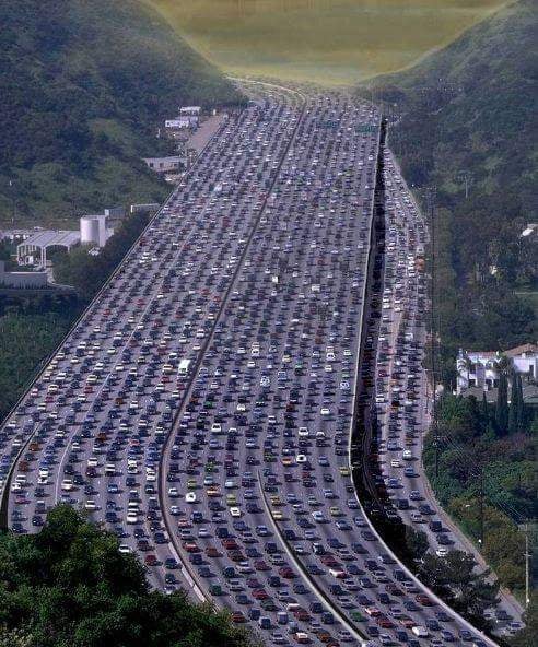
Anyone who has driven through the Sepulveda Pass during rush hour knows that traffic on Interstate 405 can be a nightmare. Still, it’s not as bad as it was made to seem in an altered photo that’s making the rounds on Facebook.
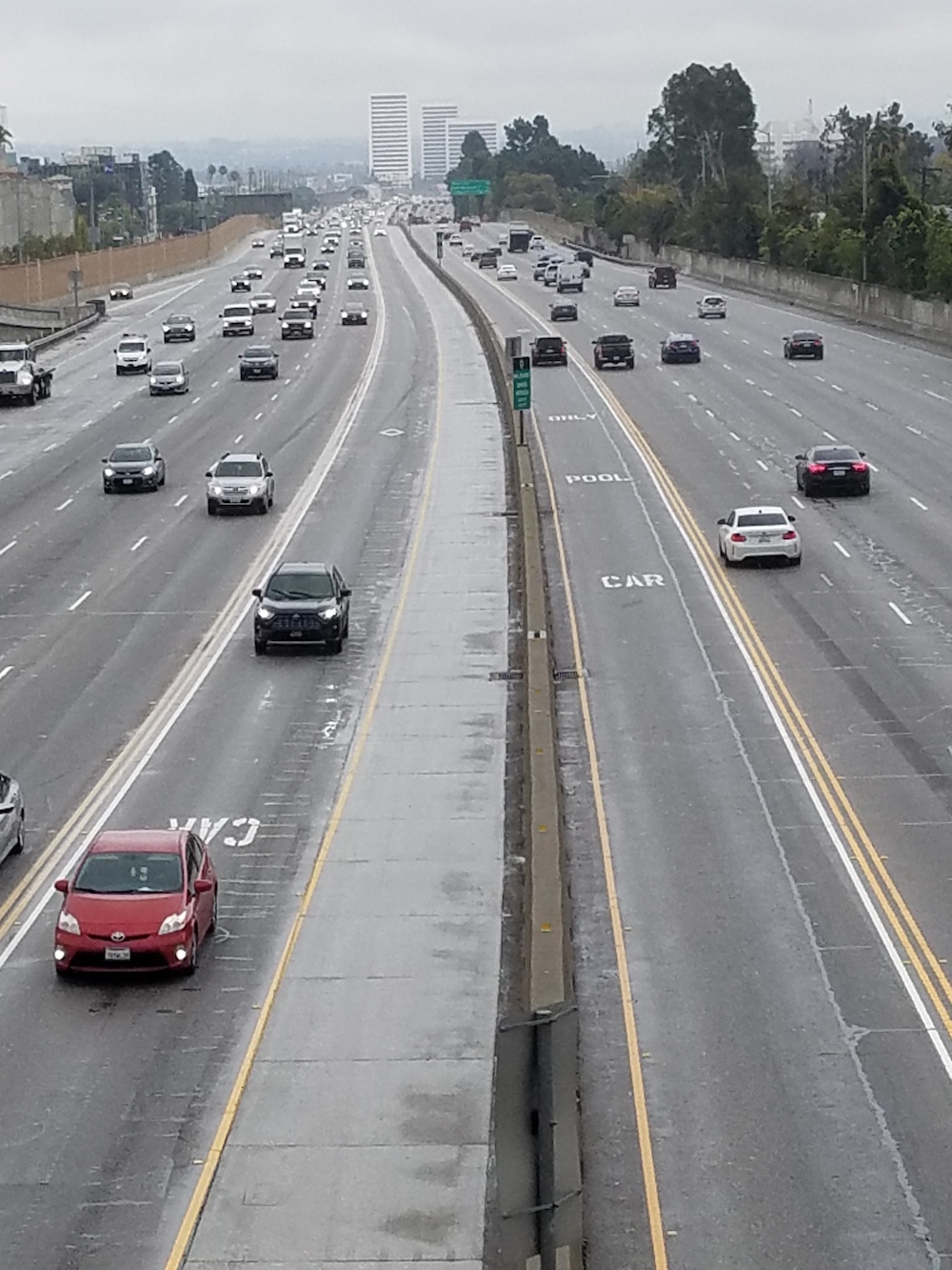
The image shows 19 (!) lanes of bumper-to-bumper traffic snaking along the freeway just north of the Getty Center, about 3 miles from the UCLA campus. And when an Associated Press reporter decided to fact-check the photo, she turned to Professor Brian Taylor, director of the UCLA Institute of Transportation Studies.
Not only did Taylor have the insight necessary to debunk the altered photo, but he even had a recent picture of the real 405 to prove it.
Here’s the fake picture:
And here’s the photo by Taylor, taken in approximately the same location (although looking southbound, the opposite direction), which offers proof that there are not 19 lanes in that stretch of freeway, but 12 — including carpool lanes in each direction that were added in 2011 and 2012 during the infamous “Carmageddon” project.
A photo of the 405 taken in March by UCLA Institute of Transportation Studies Director Brian Taylor because, he says, “who wouldn’t go around taking pictures of freeways?”
In its story about the picture, the AP provides a link to the original photograph that had been doctored to produce the viral fake, saying it appears to have been captured in 1998. It shows five lanes of traffic in each direction, with far fewer cars.
Taylor, a professor of urban planning and public policy at the UCLA Luskin School of Public Affairs, wrote to the AP reporter that the false image “has been bouncing around for years.”
“It’s a bit of obvious hyperbole to (I assume) make a point about continually widening freeways to address growing traffic levels,” Taylor wrote. “The idea that someone would take this seriously is, well, alarming.”
Thanks to the AP and Taylor, Facebook has now added a notification that the photo has been altered.