Model Identifies High-Priority Areas for Vaccine Distribution
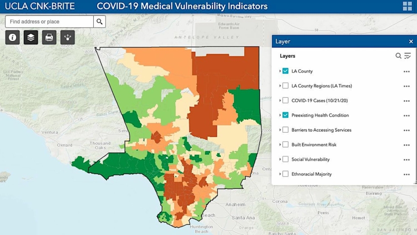
To help slow the spread of COVID-19 and save lives, UCLA public health and urban planning experts have developed a predictive model that pinpoints which populations in which neighborhoods of Los Angeles County are most at risk of becoming infected. The researchers hope the model, which can be applied to other counties and jurisdictions as well, will assist decision makers, public health officials and scientists in effectively and equitably implementing vaccine distribution, testing, closures and reopenings, and other virus-mitigation measures. The model, developed by the Center for Neighborhood Knowledge at UCLA Luskin and the UCLA BRITE Center for Science, Research and Policy, maps Los Angeles County neighborhood by neighborhood, based on four important indicators known to significantly increase a person’s medical vulnerability to COVID-19 infection — preexisting medical conditions, barriers to accessing health care, built-environment characteristics and socioeconomic challenges. The research data demonstrate that neighborhoods characterized by significant clustering of racial and ethnic minorities, low-income households and unmet medical needs are most vulnerable to COVID-19 infection. Knowing precisely which populations are the most vulnerable and where new infections are likely to occur is critical information in determining how to allocate scarce resources. The data can also provide insights to social service providers, emergency agencies and volunteers on where to direct their time and resources, such as where to set up distribution sites for food and other necessities. And importantly, identifying the areas and populations with the highest vulnerability will help decision-makers equitably prioritize vaccine-distribution plans to protect the most vulnerable. — Elizabeth Kivowitz Boatright-Simon



Leave a Reply
Want to join the discussion?Feel free to contribute!