Inequality and California Freeways: A Visual Journey Story map opens a window into the disproportionate impact on people of color of freeway routing near the Rose Bowl
By Mary Braswell
The research project was ambitious in scope, chronicling the history of racism in freeway development in California and assessing the damaging impacts that endure today.
More than 300 pages long, with 16 authors from UCLA and UC Davis, the final product is rich with data and insights about how to atone for past harms and ensure that future policies have equity at their center.
Once it was published in March 2023, the team at the UCLA Institute of Transportation Studies faced the next challenge: How best to convey the report’s findings to an audience both inside and outside academia?
To meet this goal, ITS researchers, communications specialists and graduate students tapped into storytelling tools powered by data science, opening a window into the expansive report by zeroing in on a single, illustrative case study: the decision to route the 210 freeway through a thriving Black neighborhood in Pasadena.
Using ArcGIS StoryMaps technology, the team wove together census data, charts, maps and historic photos to create an absorbing visual narrative of the planning decisions of the 1950s and ’60s that led to the displacement of nearly 3,000 predominantly Black residents.
The full report explores the siting of freeway projects in Pasadena, Pacoima, Sacramento and San José, said Claudia Bustamante, ITS communications manager, but “of all the cities that the researchers looked at, it was really Pasadena that had such a stark contrast showing what the freeway did because of its chosen route and what communities were impacted the most.”
Bustamante set out to brainstorm with ITS graduate student researcher and communications fellow Michael Rosen, whose interest in mastering the tools of data science led him to UCLA Luskin.
“A story map allows for the integration of visuals in a really cool way, and we wanted to use that specific tool to tell the Pasadena part of the story,” said Rosen, who earned his master’s in urban and regional planning in 2023. “No regular person is going to read hundreds of pages on the history of freeways, so the idea was to produce a more accessible version, looking at one slice of the report.”
Rosen distilled the 50-page Pasadena chapter into an outline for the project and worked with Bustamante to develop visual aids to tell the story. UCLA Luskin staff and students, including a team from the Center for Neighborhood Knowledge, did the heavy lifting on data analysis. Principal investigator Anastasia Loukaitou-Sideris, a professor of urban planning and now interim dean of the Luskin School, and an ITS research project manager, Jacob L. Wasserman, reviewed the work to ensure that the study’s overarching message was conveyed.
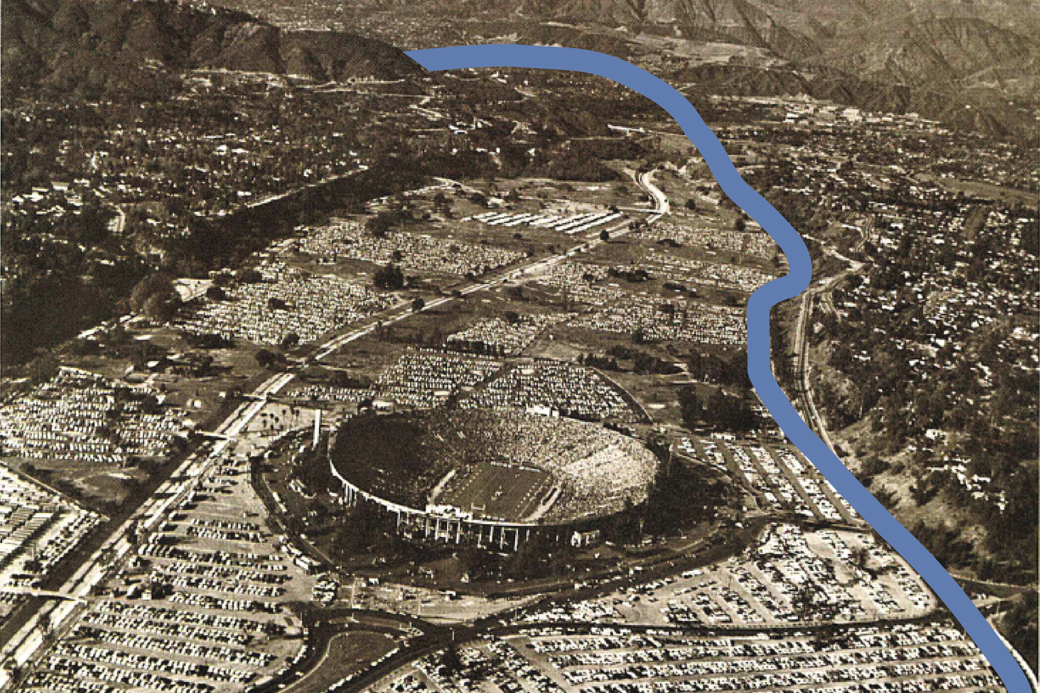
The story map recalls a time when people of color were drawn to Pasadena’s northwestern neighborhoods for the area’s lively commercial district, Victorian- and Craftsman-influenced architecture, and an air of possibility. After World War II, however, the neighborhood’s fortunes began to change. Disinvestment, redlining and demolition projects euphemistically cast as “urban renewal” all set the stage for deliberations over which route the Foothill Freeway/Interstate 210 would take.
One option, known as the “Blue Route,” would have gone through a largely uninhabited but wealthier area near the Rose Bowl. Instead, state and city officials selected the “Green Route,” which displaced eight times as many homes, mostly occupied by people of color.
The decision prioritized protection of the natural surroundings near the venerated stadium’s parking lot. As a result, a community was cut in two by the 210 Freeway, with thousands of homes and businesses demolished. Those who remained were exposed to the known health hazards of freeways such as noise and auto emissions. Home values were significantly depressed relative to other parts of Pasadena.
“It is hard to interpret this series of events as anything other than a coordinated effort by local officials over decades to displace Black residents,” the researchers concluded.
Rosen said he was grateful for the opportunity to use the skills learned through his urban planning coursework to share an important piece of research. With a background in journalism, he came to the program with an interest in finding compelling ways to convey fact-based information. He gravitated toward courses such as Urban Data Science, taught by Professor Adam Millard-Ball, and GIS and Spatial Data Science, taught by Yoh Kawano, who earned his doctorate in urban planning at the Luskin School in 2020.
That skillset helped ITS achieve its overriding goal.
“In most of our work, we ask ourselves, ‘How do we tell this story in the best way?’” Bustamante said. “Researchers are going to read the research, but that’s not our only audience.”


Leave a Reply
Want to join the discussion?Feel free to contribute!